Analyse der Schneeflächen auf Gletschern der tiroler Zentralalpen aus Landsat-Bildern
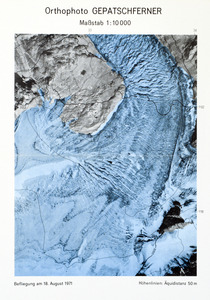
The extent of snow cover at the end of the ablation season on glaciers in the Tyrolean Alps in 1972 and 1973 was determined from Landsat-1 Multispectral Scanner (MSS) images. For snow mapping the MSS-images with a ground resolution of 80 meters were enlarged to a scale of 1:100.000 by photographic methods. Different appearance of snow cover in the 4 MSS-channels is discussed in connection with ground truth control. The accuracy of snow and ice mapping from Landsat images was checked on 15 glaciers with an area from 1 to 10 km**2 by aerial photography and/or ground truth control. These comparisons imply the usefulness of Landsat images for snow mapping on glaciers of a few square kilometers. The altitude of the equilibrium line was determined from Landsat images for 53 glaciers in the Tyrolean Alps. The regional differences in the equilibrium line altitude correspond to the regional precipitation patterns. The equilibrium line was identical with the snow line at the end of the budget year 1971/1972; therefore it was possible to determine the equilibrium line from satellite images. For 1968/69 the equilibrium line was mapped from aerial photographs for several glaciers. In 1972/73 mass balance was strongly negative and the equilibrium line was within the firn area of the glaciers. Therefore it was not possible to distinguish between accumulation and ablation areas from the Landsat images of September 1973; however, snow and ice areas could be clearly differentiated. The ratios of accumulation area or snow area to the total area of the glaciers were determined from satellite images and aerial photography separately for advancing and for retreating glaciers and were related to the mass balance. In the budget years 1968/69 and 1972/73 with negative mass balance the accumulation area ratios of the advancing glaciers were clearly different from the ratios of the retreating glaciers, in 1971/72 with positive or balanced mass budget the differences between advancing and retreating glaciers were not significant.
![[thumbnail of Rott-1976_gepatschferner-beilage3.jpg]](https://epic.awi.de/31446/7/Rott-1976_gepatschferner-beilage3.jpg)

![[thumbnail of Rott-1976_gepatschferner.jpg]](https://epic.awi.de/31446/8/Rott-1976_gepatschferner.jpg)


 Edit Item